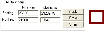
The site boundary determines the easting and northing coordinates that will be used in all SADA functions. (The vertical component is determined by the Set Vertical Layers section.) Note: Even if a polygon extends outside of the site boundary, the site boundary still determines the data extends, and the points within the polygon outside of the boundary are ignored.
When Set up the site is selected in the Steps Window, the Parameters Window displays the site boundary information.
Default easting and northing minimum and maximum coordinates are determined by SADA based on the data upon file creation. For an empty sada file, SADA sets both minimum values to zero and maximum values to 1.
To adjust these coordinates, manually enter appropriate values in the text boxes and press the Apply button. Alternatively, select the Draw button and use the mouse to select a rectangular area of interest in the Graphics Window. Press the Apply button to view the full effect.
Use the Snap button for SADA to snap the site boundary back to the full data or model extents. Then press Apply to view the full effect.
Note: If site boundaries are set before GIS overlays are imported, SADA will ask the user if boundaries should be adjusted to incorporate the layers during their import.